%20(1).png)
Backpacking - Coyote Gulch 10/21-22/22
- Emily Hacken

- Oct 25, 2022
- 5 min read
This is a bucket list item!! Arches, cliff walls, waterfalls and springs. The perfect Southern Utah backpacking trip.

Itinerary:
Day 1 - Carpooling - 7:00 am (6 hr drive)
Drive to Trailheads (36 miles down Hole in the Rock Rd, turn left onto Fourty Mile Ridge Rd, 5
miles to Water Tank Trailhead, 2.5 miles sandy rd to Coyote Gulch Access - 4WD or AWD)
1:00 pm- Set-Up Shuttle - Water Tank Trailhead/Coyote Gulch Access
Water Tanks - Coyote Gulch Trailhead - Sneaker Route (Exit)
Coyote Gulch Access point (Entrance)
2:00 pm - Trailhead (Coyote Gulch Access Point)
2:00 - 6:00 pm - Hike to Camp (around Cliff Arch area)
6:00 pm - Set Up Camp
6:30 pm - Dinner
Swimming Hole (optional)
Day 2 -
7 am - Wake up
8:00 am - 12:00 pm - Hike along river/Coyote Bridge/Jacob Hamblins Arch and Lunch
1:00 pm - Hike Out
2-3:00 pm - Back at Vehicles
5:00 pm - Dinner in Escalante (Escalante Outfitters) - (1.5 hr drive)
10:00 - 11:00 pm - Home - (4.5 hr drive)
Activity: Backpacking Coyote Gulch - 14 mile loop from Water Tank Trailhead, into the canyon and then out the next day, to Coyote Gulch Trailhead.
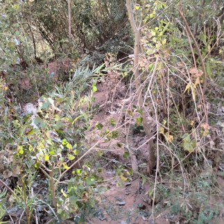
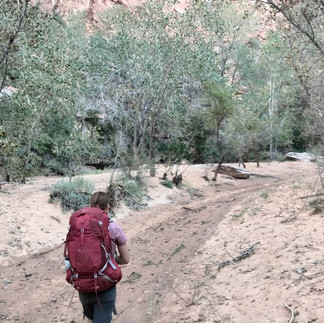
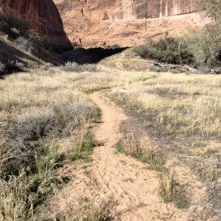
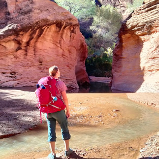
Day 1 - 6.5 miles. Start at Coyote Gulch Access Point Trailhead. Hike 2.5 miles across flat desert to Crack in the Wall. Descend about 1 mile through crack and down huge sandy hill to riverbottom. Hike upstream about 3 miles to Cliff Arch area to camp. Multiple stream crossings 13+. Several waterfall springs on rt. Better camping closer to Cliff Arch. Bushwacking trail at times. Play in swimming hole. (Note on Camping - there are MANY camping spots all along the entire river trail from 1-10 tents)
(Stevens Arch Hike - 1 mi round trip. Trail on south side of river, then in river. Meets Escalante River and head upstream. Deeper river with rocky river and thick brush banks, poor trail. Very difficult to navigate - NOT recommended - takes about 1 1/2 hr)
Day 2 - Hike upstream another 4.5 miles through Coyote Arch to Jacob Hamblins Arch (about 2-3 hr).
Takes about 1 1/2 hr from Cliff Arch to Coyote Arch. Some bushwacking, mostly good trails, wider canyon.
30 min to "Slot". Deep water for wading or hike left.
15 min Swiss Cheese Falls - don't miss it on the right, need to hike below for best photos.
Cairn on left before Jacob Hamblin's Arch to mark climb out. Don't miss hiking around and behind the arch. Great for lunch.
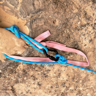
Ascend 150 ft sandstone slope (bring handline to assist) to the canyon rim. About 15 ft scramble, then flat area and then another about 100 ft 30-40 degree scramble - rope is great with heavy packs. Anchor is off a hole in a rock about 3 in wide.
Hike 2 miles across flat desert/rock to Water Tank Trailhead. About 2/3 uphill sandstone, then 1/3 flat sand.
*If you take the "Shortcut Route" to Coyote Access instead of Water Tank, use Gaia map app. The cairns are very sparse and difficult to navigate. Cross under a barbed wire fence.
Optional Side Trip - Devil's Garden - Hole in the Rock Rd on the way out.
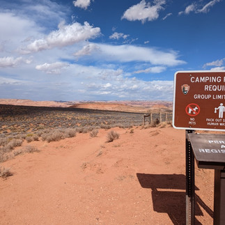
Gear: Thin T-shirt, thin long-sleeve shirt, fleece, thin puffy coat, rain jacket, shorts or thin hiking pants, running shoes, 3-4 L water bottles, water filter (can rent), 8-10 snacks, 65+ liter backpack with waistbelt, sunscreen, sunglasses, hat, first aid kit, sleeping bag (20-30 degrees - down is preferred) (can rent), sleeping pad (can rent), tent (can rent), headlamp, pj's, toiletries, dehydrated or backpacking meals, WAG bag (2 gallon ziplock bags with kitty litter for pooping), cooking stove (No campfires), compass
Tips:
Driving Hole in the Rock Road - mostly washboard with several sandy river bottom crossings. Speed limit is 35 mph. We found driving 35-40 mph was best on washboard - too slow it will kill your vehicle, too fast and you can slide off on the turns. River crossings have 1-2ft drops in and then out of them, so have a vehicle that has good clearance or take at an angle. Turn off from Fourty Mile Rd to Water Tank Trailhead is moderate washboard. From Water Tank to Coyote Gulch Access is SAND. No problem for AWD or 4WD.
Water - The river is super silty, not fun to filter and will quickly clog your water filter. However, there are a few running springs coming out of the rock along the way. These are more towards the first half of the hike once you get down to the river area.
(I drank 1L of water while driving down Hole in the Rock Road. I had about another during the desert crossing, down the sand hill and along our little side journey to Steven's Arch and back to Coyote Gulch. I filled my 2 x 1L reservoirs and my belly at a spring in Coyote Gulch. Also boiled river water for the night. This lasted me all the next day along the river, up the exit point, across the desert and back to the car.)
Gear: 45+ liter backpack with waistbelt, 3 L water in water bottles, water filter, stove and fuel (if cooking food), spoon or fork, camping knife or multitool, tent, sleeping pad, sleeping bag rated to 30 degrees (down preferred), synthetic T-shirt, thin long-sleeve synthetic shirt, fleece, thin puffy coat, rain jacket, shorts or thin hiking pants, thin synthetic pant for sleeping, running shoes, neoprene socks (optional), sandals with a back strap, 2 pairs of socks, 8-10 snacks, dinner, breakfast, sunscreen, sunglasses, hat, first aid kit, headlamp, toiletries, WAG bag (2 gallon ziplock bags with kitty litter for pooping), 100-150 ft rope for Jacob Hamblins Arch climb out and lowering packs down Crack in the Wall, Gaia map app - download area Fri morning
For Fall/Winter Camping - Beanie, layered with a hooded jacket of some kind or a buff to keep beanie in place while you sleep, thick gloves, wool socks for sleeping in don’t sleep in socks that you hike in, warm dry comfy clothes to change into in the car
Rentals (for 2 days):
1. Tents (2 man - $13, 4 man - $22 BYU Outdoors Unlimited; 2 man - $14, 4 man - $18 UVU Outdoor Adventure Center)
2. Sleeping bags (0 degree - $22, 30 degree - $22 BYU Outdoors Unlimited; 0 degree - $14, 30 degree - $10 UVU Outdoor Adventure Center)
3. Sleeping pads (thermarest - $9 BYU Outdoors Unlimited; thermarest - $8 UVU Outdoor Adventure Center)
4. Backpacks (85 liter - $12 BYU Outdoors Unlimited; 65 liter - $14 UVU Outdoor Adventure Center)
5. Stove with fuel ($8 BYU Outdoors Unlimited; $8 UVU Outdoor Adventure Center)
6. Mess kit ($8 BYU Outdoors Unlimited; $10 UVU Outdoor Adventure Center)
7. Water Filter ($6 UVU Outdoor Adventure Center)


Turn off for Fourty Mile Ridge Rd, sandy road to Coyote Gulch Access Trailhead, Water Tank Trailhead parking area


Hike from Coyote Access Trailhead to Crack in the Wall


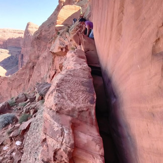


Crack in the Wall
Above Crack in the Wall
Crack in the Wall Upper Section 1/2 - 1 1/2 feet wide
Crack in the Wall Upper Section 2/2
Crack in the Wall Lower Section 1/2 - 1 ft wide (can walk above on 1 1/2 ft wide ledge 15 ft up)
Crack in the Wall Lower Section 2/2


Crack in the Wall - lowering packs in Middle Section (30 ft)


Hike down sandy hill to Coyote Gulch (about 1 mile); Stevens Arch is visible - about 30 min


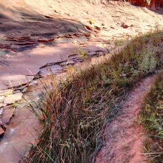

Hike up Coyote Gulch

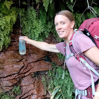


Spring on right about 10 min from start of hike in Coyote Gulch


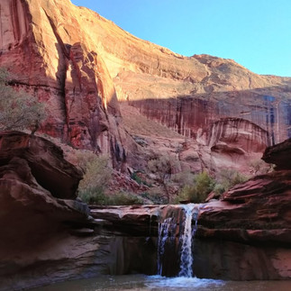


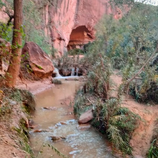
Hike to Cliff's Arch (many stream crossings)


"Green Cove Camp Area" just downstream on left of Cliff Arch


Hike up Coyote Gulch


Coyote Arch (1 hr upstream from Cliff Arch)


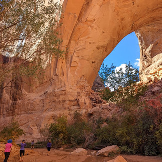
"Slot" - can wade or hike left; Swiss Cheese Falls; Jacob Hamblin Arch


Scramble out of Jacob Hamblin Arch area


Hike out to Water Tank Trailhead


Comments